Maps
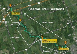
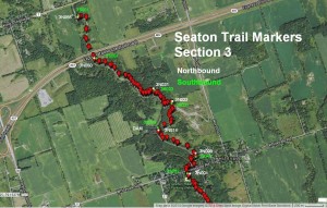
Seaton Trail overlayed on Google Maps:Printable Maps:
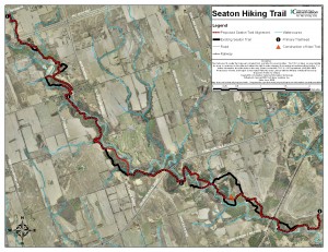
- Seaton Trail Map
- Regional – as shown above (1650 x 1275 jpg)
Reaching The Trail:
NORTH: The entrance is located on the south side of Highway 7 at Green River, approximately 8 km east of Markham. Watch for the Seaton Hiking Trail sign beside a long driveway, accessing the trail parking lot. Coordinates: N43.90110 W79.17664
SOUTH: Take Brock Road north from Highway 401 and turn west on the 3rd Concession. Parking is available on the roadside, at the deadend of the road but outside the gate to the Brock West Landfill site. A large sign shows access to the trail. Coordinates: N43.86403 W79.09846
HAMLET OF WHITEVALE: Park in the community park on the south side of Whitevale Road, on the west side of the river. The trail goes south out of the park, on the west side of the river. Going north, cross the bridge to the east side of the river and look for the sign. Coordinates: N43.88649 W79.16267
TAUNTON ROAD: From Taunton Road, south on Whites Road. Turn east onto Forestream Trail. Before the river turn south and continue a short distance to the parking lot. Coordinates: N43.86954 W79.13171
Trail Markings:
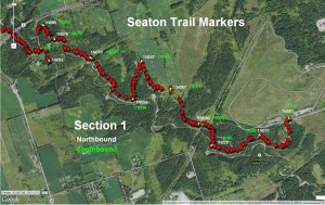
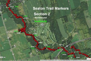
Originally red rings painted on trees were used for the main trail route and yellow for side trails. Double rings indicate a turn. The original trail markings can still be seen in many locations, but are becoming faded.
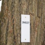 White metal blazes are now placed along the entire length of the main trail. These blazes are numbered to assist volunteers, contractors and emergency personal to locate work sites and problem areas.
Sections of Trail:
1 – Concession 3 to Forestream Trail
2 – Forestream Trail to Whitevale
3 – Whitevale to Green River
Direction of Trail:
S – Southbound
N – Northbound
 Sequential number:
### – Sequential number, beginning with 001 at the start of each section
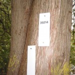
An example of blaze numbering: 3N014
3 = Whitevale to Green River section
N = Northbound
014 = Sequential number, beginning with 001 in Whitevale Park Trailhead increasing heading north
Single Blaze – trail proceeds straight ahead
Double Blaze – turn left if top blaze is to left of bottom blaze and turn right if top blaze to the right of the bottom blaze
Use the trail at your own risk because blazes can be lost due to tree falls and vandalism and the trail is frequently shifted due to erosion.
Disclaimer: We make no promise that these maps are currently accurate. Since its creation, the trail and its physical environment have undergone many changes in route and structure. New maps are being developed.
Latest News
Construction of Stormwater Management Facility Outfall
March 24, 2020
UPDATE. THE CONSTRUCTION HAS BEEN COMPLETED AND THE TRAIL IS OPEN The Seaton Hiking Trail will be temporarily closed northeast of the Foreststream Trail (Old Whites Road)…
March 24, 2020
UPDATE. THE CONSTRUCTION HAS BEEN COMPLETED AND THE TRAIL IS OPEN The Seaton Hiking Trail will be temporarily closed northeast of the Foreststream Trail (Old Whites Road)…
Seaton Community Northern Outflow Project Flooding
October 8, 2019
Users of the Seaton Trail just south east of Forestream Road and at the Hydro line would have noticed flooding of the trail. The flooding is the result of the new Mattamy Homes…
October 8, 2019
Users of the Seaton Trail just south east of Forestream Road and at the Hydro line would have noticed flooding of the trail. The flooding is the result of the new Mattamy Homes…
Seaton Community Southern Outflow Project
October 8, 2019
Users of the Seaton trail just north of the CPR trestle would have noticed the new Seaton Community Southern Outflow Project. This project collects rain water from the new…
October 8, 2019
Users of the Seaton trail just north of the CPR trestle would have noticed the new Seaton Community Southern Outflow Project. This project collects rain water from the new…
Found Glasses on Trail at Marker 1N085
November 21, 2018
A pair of kids glasses were found on the trail around marker 1N085. The glasses were left at the marker.
November 21, 2018
A pair of kids glasses were found on the trail around marker 1N085. The glasses were left at the marker.
Latest Events
Seaton Trail Race
May 10, 2014
The Seaton Trail Race consists of 3 races: 15K/25K and 50K. The 15K will start 8:30am at Pine Ridge and the turnaround will be at Forestream. The 25K will start 8:00am at Pine Ridge…
May 10, 2014
The Seaton Trail Race consists of 3 races: 15K/25K and 50K. The 15K will start 8:30am at Pine Ridge and the turnaround will be at Forestream. The 25K will start 8:00am at Pine Ridge…
BTC Seaton Trail Hike – May 15th
May 15, 2011
Introduction to the Seaton Trail to Bruce Trail Conservancy Memebers. The trail follows West Duffins Creek that winds through a riparian habitat, all within Pickering,…
May 15, 2011
Introduction to the Seaton Trail to Bruce Trail Conservancy Memebers. The trail follows West Duffins Creek that winds through a riparian habitat, all within Pickering,…
Toronto Outdoor Club Winter Night Hike – Wed, Jan 26 2011
January 26, 2011
We’re going to walk the first section of the Seaton Hiking Trail starting from south end parking lot (Coordinates: N43.86403 W79.09846). Depending on the condition, we…
January 26, 2011
We’re going to walk the first section of the Seaton Hiking Trail starting from south end parking lot (Coordinates: N43.86403 W79.09846). Depending on the condition, we…
Install Un-Authorized Use Signs On Sunday Oct 17, 2010
October 17, 2010
Here’s your chance to give back to the Seaton Trail. We are planning some trail work on Sunday Oct 17, 2010 and we are looking for volunteers. We will be meeting at Rossland…
October 17, 2010
Here’s your chance to give back to the Seaton Trail. We are planning some trail work on Sunday Oct 17, 2010 and we are looking for volunteers. We will be meeting at Rossland…


